Why Satellite Data Is Never Perfect
7 Sources of Uncertainty in Satellite-Based Agricultural Insurance
Satellite imagery has become an essential tool for agricultural monitoring, crop insurance, and environmental assessment. But satellite data is not a perfect representation of reality — and understanding its limitations is just as important as understanding its capabilities.
Most people are familiar with satellite imagery through navigation apps. But agricultural remote sensing goes far beyond what Google Maps shows. Satellites collect data across parts of the electromagnetic spectrum invisible to the human eye, near-infrared (NIR), shortwave infrared (SWIR), thermal infrared, and radar. Some missions, like GRACE, measure changes in Earth’s gravity field to estimate groundwater depletion.
At Zetarium, we primarily use Sentinel satellite imagery to develop crop infrastructure analytics products. Since the 1960s, scientists have built a vast body of research demonstrating how spectral signatures can identify real-world phenomena in agriculture, forestry, and natural resource management.
Despite these advances, satellite-based agricultural monitoring carries multiple sources of uncertainty that affect crop monitoring systems, agricultural insurance products, yield estimation models, and risk assessments.
Many well-known technical issues are addressed through standard preprocessing, radiometric correction, geometric correction, atmospheric correction, and sensor calibration. Modern data providers typically perform these steps before imagery reaches users. But many important sources of uncertainty remain.
Uncertainty can enter at every stage of the processing chain:
Reality → Satellite Observation → Image Processing → GIS Integration → Machine Learning → Insurance Assessment
This post covers the seven most important sources from the perspective of satellite-based agricultural insurance.
A. Observation Availability Uncertainty
The first category concerns whether usable satellite data exists at all, and whether it accurately captures what happened on the ground during the observation window.
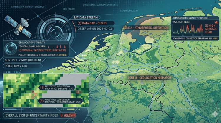
1. Cloud Coverage
Clouds are the most obvious limitation of optical satellite imagery. Visible and near-infrared sensors cannot penetrate cloud cover; instead of observing farmland, they record the cloud layer itself.
This becomes critical when important agricultural events occur during extended cloudy periods. Even with the frequent revisit times of Sentinel satellites, persistent cloud cover can block usable observations for several consecutive weeks.
For agricultural insurance, this may delay the detection of drought stress, flooding, hail damage, or other insured events — sometimes by long enough to affect the claim assessment entirely.
2. Thin Clouds, Haze, Dust, and Atmospheric Effects
The problem is not limited to thick clouds. Thin clouds, atmospheric haze, dust storms, aerosols, humidity, and water vapor can all distort the signal received by the satellite.
In many cases, the image still appears usable, but the measured reflectance values are compromised. Atmospheric correction algorithms reduce these effects significantly, but cannot eliminate them. This issue is especially relevant in arid and semi-arid regions where dust events are common.
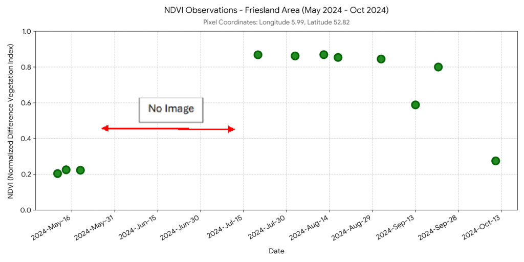
3. Temporal Sampling Error
Satellites do not continuously observe the Earth. They capture snapshots at fixed intervals, which means important agricultural events can occur between two observations and leave little or no trace by the time the next usable image is acquired.
Consider a straightforward scenario:
- A hailstorm occurs on Day 2
- A satellite passes on Day 5, but clouds block the view
- The next usable image arrives on Day 15
By that point, some evidence of the event may have already disappeared. For agricultural insurance, this creates an unavoidable gap between what happened and what can be observed.
B. Spatial Attribution Uncertainty
Even when a clear satellite observation exists, a separate class of uncertainty concerns which farm the signal actually belongs to. The mixed pixel problem, georeferencing accuracy, boundary delineation errors, and neighborhood effects all come down to the same core question: does this pixel represent the insured field, or something else?
4. Mixed Pixel Problem and Sparse Canopy Effects
A Sentinel-2 pixel typically covers an area of approximately 10 by 10 meters. Within that area, a single pixel may simultaneously contain:
- crop canopy,
- bare soil, roads,
- irrigation channels,
- weeds,
- farm infrastructure
The recorded signal is an average of everything inside that pixel; the satellite does not observe individual plants, but a mixture of all objects within the observation area. This limitation becomes increasingly important in smallholder farming systems where individual parcels are small relative to pixel size.
The problem is especially severe in orchards and horticultural systems. Trees are often planted with substantial spacing to optimize sunlight, airflow, and yield. In many orchards, bare soil between trees occupies more area than the canopy itself. As a result, vegetation indices such as NDVI may significantly underestimate actual tree condition.
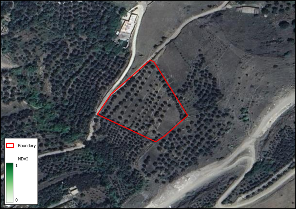
This affects perennial crops, including pistachios, olives, citrus, dates, and other orchard systems, precisely the crops where accurate insurance assessment is most commercially significant.
5. Parcel Attribution Uncertainty
This section brings together three related issues, georeferencing accuracy, farm boundary delineation errors, and neighborhood effects, because they all answer the same fundamental question: which farm does this satellite signal actually belong to?
Georeferencing accuracy.
Agricultural insurance systems depend on integrating satellite imagery, farm boundaries, farmer records, weather data, and insurance databases into a single geospatial system. These datasets are rarely collected using the same methods or positioning systems. Even small geolocation discrepancies (a few meters of displacement) can cause pixels from a neighboring farm to be incorrectly included in an assessment.
Farm boundary delineation errors.
Smartphone applications have made field mapping more accessible, allowing farmers and surveyors to draw boundaries manually against satellite imagery backgrounds. But this approach introduces several sources of error:
- GPS inaccuracies
- Human interpretation errors
- Outdated background imagery
- Incorrect parcel identification
- Inconsistent surveying procedures
Even a carefully drawn boundary may not precisely match the actual field edge.
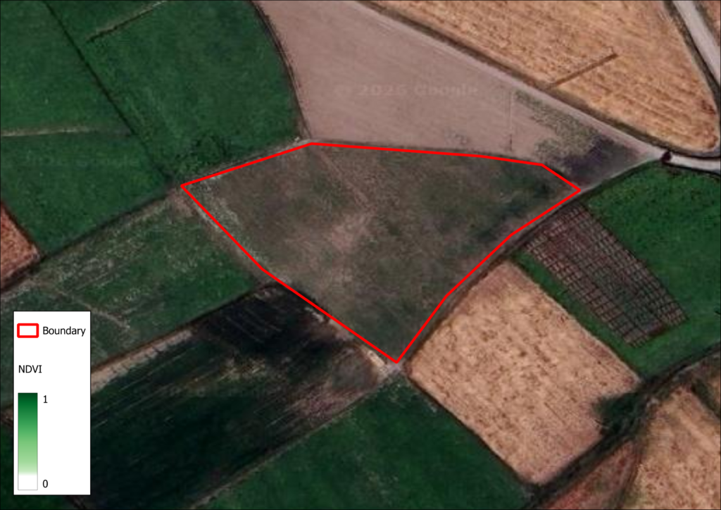
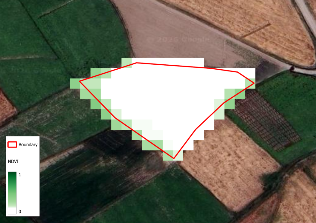
Figure 3: Parcel attribution uncertainty caused by boundary inaccuracies and neighboring field effects.
Neighborhood effects.
Agricultural fields do not exist in isolation. A pixel located near a field boundary may contain information from two neighboring farms simultaneously. If one field is irrigated while the adjacent one is stressed, the resulting signal does not accurately represent either farm. From an insurance perspective, this is not just optical contamination; it is the practical challenge of separating one farmer’s agricultural reality from another’s when both are captured within the same pixel.
C. Modeling Uncertainty
Even with clean observations correctly attributed to the right parcel, further uncertainty arises in how those observations are interpreted.
6. Crop Classification and Model Transferability
Time-series analysis of vegetation indices like NDVI is the most widely used approach for crop classification. Different crops exhibit distinct seasonal growth patterns, and machine learning algorithms use these patterns to identify crop types.
However, several challenges persist:
- Different crop species may exhibit similar seasonal behavior
- Climate variability can alter growth patterns from year to year
- Different management practices produce different spectral signatures for the same crop
- Models trained in one region frequently perform poorly when applied elsewhere
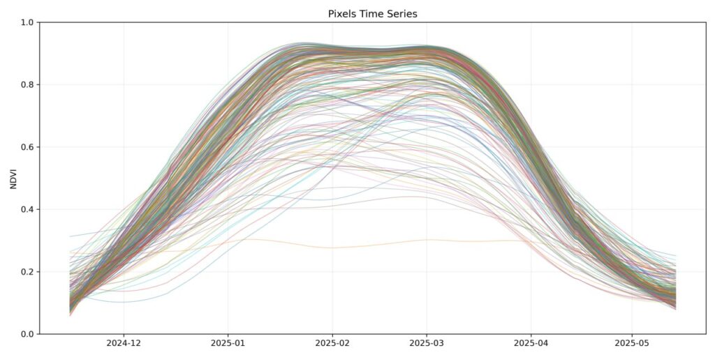
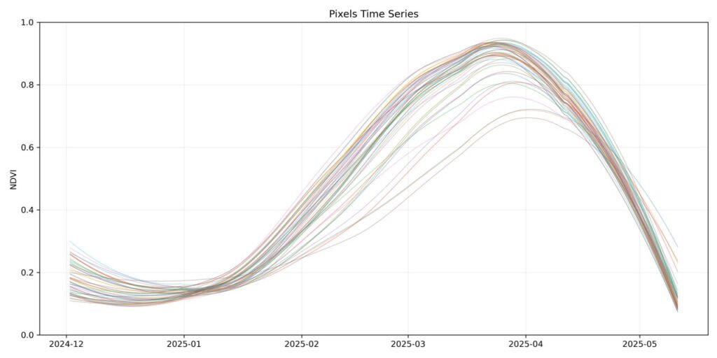
Figure 4: Two wheat fields located only a few kilometers apart exhibit substantially different NDVI trajectories due to differences in management practices or local conditions.
Agriculture is highly local. Differences in climate, soil conditions, irrigation practices, crop varieties, and farmer behavior all influence model performance. Crop classification systems, therefore, require regional calibration and ongoing improvement.
D. Agricultural Reality Uncertainty
7. Complexity of Real Farming Systems
After years of working with agricultural data, we have come to believe that the most difficult source of uncertainty is not technical.
It is reality itself.
Agriculture is not merely a biological process. It is shaped by culture, economics, tradition, and local knowledge that no satellite can directly observe.
A concrete example:
Saffron is typically a multi-year crop that grows in autumn, flowers in November, continues through spring, and enters dormancy in summer. In some regions, farmers allow livestock to graze on saffron fields after the growing season, using the under-dry biomass as animal feed. A remote sensing analyst unfamiliar with this practice may misinterpret the resulting vegetation patterns entirely.
We have documented other related cases in research published by Springer, where local agricultural practices produced outcomes that were difficult to anticipate using conventional assumptions alone.
These experiences point to an important lesson: many uncertainties do not originate from satellites, sensors, algorithms, or machine learning models. They originate from the complexity of human behavior and agricultural systems. No matter how sophisticated remote sensing becomes, understanding local farming practices will remain essential.
Final Thoughts
Satellite imagery is one of the most powerful tools available for agricultural insurance. It enables monitoring at scales that would be impossible through field visits alone.
But satellite imagery should not be viewed as a replacement for field observation. It is an additional source of evidence; one that carries its own uncertainties, which must be understood, quantified, and managed appropriately.
The goal is not to eliminate uncertainty. That is not possible. The goal is to understand it, quantify it, and manage it appropriately.
Only by combining remote sensing, GIS, agronomy, local knowledge, and actuarial expertise can agricultural insurance systems be built that are both scalable and trustworthy.